Water Utility Project Clearcuts Portion Of McCommas Bluff Preserve
I know that the soil in the river bottoms is so fertile that a bulldozer charging through the understory will be brushed off by the surrounding woods in a matter of weeks. A space opens and something nearby jumps into the fray to take the place. I also know that the Trinity River serves as the mother of all utility right of ways for gas, sewage, fiber optic cable and freshwater mains from area lakes. You have to break a few eggs to make an omelet. I realize the importance of utility right of ways and the need to keep them free of debris, brush and trees. If a company wanted to drill a gas or oil well down there I would be all for it. This time it’s different.
I’m also probably guilty of not mentioning the somewhat difficult circumstances I encounter on a regular basis in the Trinity Forest. The illegal dumping, near constant sound of distant gunfire, butchered animal parts, marijuana farms, burned vehicles. I can look past that with a 1000 yard stare knowing distractions like that help keep some of the more special places, special. This time it’s different.
McCommas Bluff has been a focal point of human activity for centuries. It was first mapped by the French explorers. It was first settled by William Shelton in the 1840s, an Illinois veteran from the Mexican War. The bluffs carried his name, Shelton’s Bluff until shortly after the Civil War. In 1850, he married into the Dawdy Family who ran a ferry service on the Texas National Highway across the Trinity River downstream a few miles. Pronounced “Dowdy”, the misspelling took and Dowdy Ferry Road is now over the old Texas National Highway route. Shelton, the Dawdy and Beeman families were all Illinois natives and they knew each other prior to immigrating to Texas. Dawdy and Beeman also appear together on muster roles for Bird’s Fort. Together the three families owned most of the land along the Trinity just south of what is now Fair Park to Hutchins, in what was then Nacogdoches County in the Republic of Texas. The McCommas family purchased the Shelton land after the passing of William Shelton. The name Shelton’s Bluff stuck through the Civil War, eventually changing names to McCommas Bluff on maps in 1880.
When efforts were made to navigate the Trinity River for the first time in the late 1800’s, McCommas Bluff for a brief time was a beehive of activity. Land for a inland port was platted and surveyed. Some homes, a few businesses and a wharf for moving bales of cotton was even constructed. McCommas Bluff served as a staging center for cotton, bales were barged south to Porter’s Bluff near present day Rice, Texas where they were put on larger barges before heading for the the coast. Nothing ever came of the plan since the river was not suited for boat traffic of that type.
In 1986, to commemorate the Texas Sesquicentennial , twin Texas Historical Markers were erected by the Texas Historical Commission to commemorate the history of the Trinity River. Identical historical markers were placed at McCommas Bluff and Reunion Plaza(near Reunion Tower). They read:
Since the founding of Dallas, many of the city’s leaders have dreamed of navigation on the upper Trinity River, but none of their attempts achieved lasting success. Fluctuating water levels and massive snags in the river below Dallas hindered early navigation. In 1866 the Trinity River Slack Water Navigation Co. proposed dams and locks for the waterway. Capt. James H. McGarvey and Confederate hero Dick Dowling piloted “Job Boat No. 1” from Galveston to Dallas, but the trip took over a year. In 1868 the Dallas-built “Sallie Haynes” began to carry cargo southward. Rising railroad freight charges spurred new interest in river shipping in the 1890s. The Trinity River Navigation Co., formed in 1892, operated “Snag Puller Dallas” and the “H. A. Harvey, Jr.,” which carried 150 passengers. The “Harvey” made daily runs to McCommas Bluff, 13 miles downstream from Dallas, where a dam, dance pavilion, and picnic grounds created a popular recreation spot. In 1900 – 1915 the U. S. Government spent $2 million on river improvements, including a series of dams and locks, before World War I halted work. A critical 1921 Corps of Engineers report ended further federal investment. Despite sporadic interest in later years, the dream of Dallas an an inland port remains unrealized.
———-
You can walk right out of Reunion Tower and see the historical marker. It’s twin at McCommas Bluff was stolen a number of years ago and never replaced. The post to which the historical marker was affixed remained. Until last week. When it was bulldozed. It had sat there since 1986, a relative newcomer to McCommas Bluff. The trees around it, while somewhat short in stature, varied in age from 50 to over 125 years old. Trees that witnessed most of the history mentioned above. They managed to survive the dozen other pipeline projects, gas line installations and water main redos.
I know how much fun running a chainsaw can be. Even better when you can just cut down stuff and not have to bother with cleaning it up. The photos below are before and afters of what it looked like as little as a month before the clearing began.
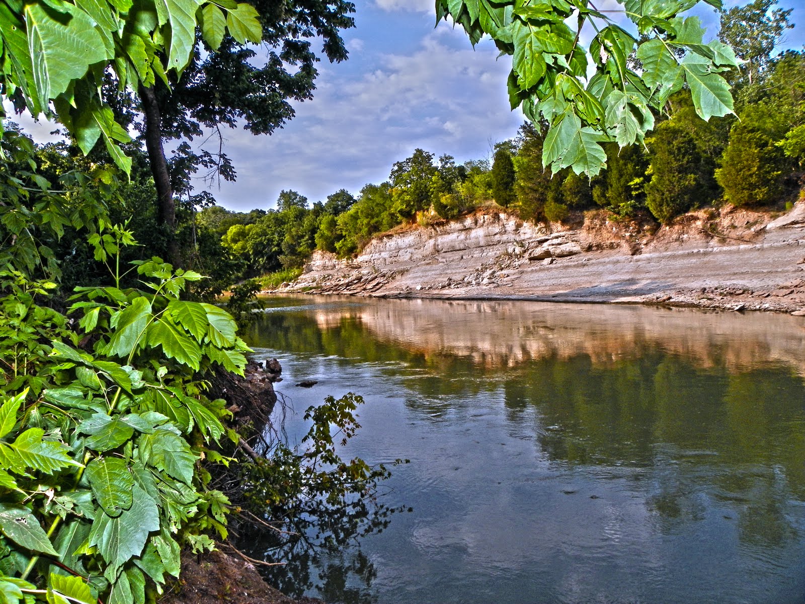 |
| McCommas Bluff July 2011 |
One of the highlights of visiting the Great Trinity Forest for me is my usual turn around point, the end of the trail, what is usually a somewhat spectacular early evening view of McCommas Bluff from the far bank. It’s about 20 miles from home, halfway. Makes you feel like you have been to some far off place seeing a piece of geography better suited for the Hill Country. I’m sure if it was in the Hill Country along the Guadalupe or Frio, Willie Nelson would have written a song about it. Making it here from where I live in North Dallas is usually no small feat, navigating the roads down to White Rock Lake, then south through what are the toughest and possibly most dangerous neighborhoods in Dallas.
 |
| McCommas Bluff August 2011 |
Both photos were taken virtually in the same spot. The large tree trunk in the foreground was from a 65 year old tree. Like I mentioned above, I respect the need to clear right of ways for projects. The results are somewhat drastic. Especially when one does not clean up after themselves.
 |
| Mountain bike ride with DORBA members April 2011 Great Trinity Forest |
 |
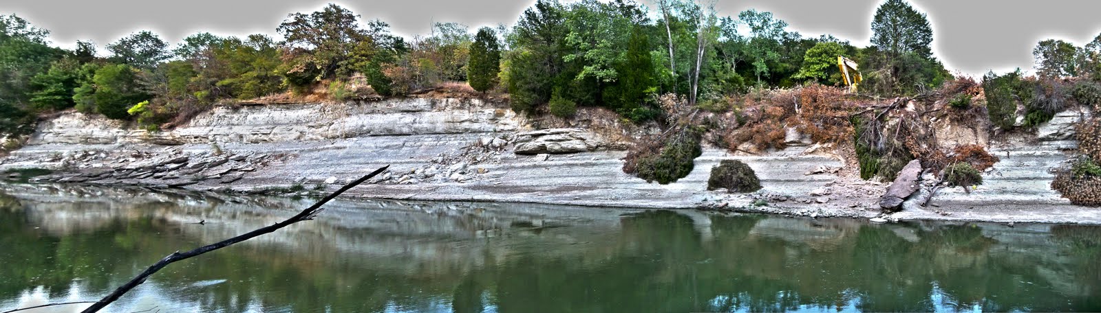
| August 2011 |
Both photos were taken within 50 feet from one another. The cedars chopped down on the far bank have tree rings noting 50-125 years of growth on them. The trees that are closest to the waters edge show evidence that they had been sitting over a week. August 13th as a result of a rainstorm, the river rose three feet. The tree debris closest to the water shows mud lines where the river submerged the branches. You can also see a pipe with a layer of concrete over it running vertically down the bluff. This is the ROW for utilities. I would gather that in the past, any construction did not need such a large footprint to accomplish their construction.
 |
| McCommas Bluff July 2011 |
 |
| McCommas Bluff August 2011 |
It’s just not the trees that are gone. It’s the view. Arguably the only naturally photogenic piece of property on the Trinity, the view is damaged for a lifetime. Trees that grow on nearly bare limestone take many decades to grow. The trees chopped down cannot be replaced. I’m feel fortunate that I had the opportunity to take some photos of the bluffs and climb all over them before the clearing took place.
It’s easy to answer the question of why this happened. Simple. They are working on a large water main. The harder question to answer is if the city and county are really serious about turning the “Great Trinity Forest” into a place that will attract an average person. Clear cutting the entrance to a nature preserve is probably not the way to do that.
They have budgeted an amount for the Great Trinity Forest equal to what it cost to build the new Dallas Cowboys Stadium. With little to show for it. Upstream from McCommas Bluff, just a 15 minute walk up the trail, they stage feel good tree plantings of small saplings at the Trinity River Audubon Center. The goal is to change the perception people have about the surrounding woods and how past transgressions of illegal landfills and pollution are things of the past. Downstream, just a 15 minute walk down the trail, is Gateway Park where the city and county have invested at least a million dollars to build a grand southern gateway to the Great Trinity Forest. You know where the Audubon Trail and the Gateway Trail meet? Yep. Right at that big bulldozed mess at the McCommas Bluff Preserve.
I know some people would be outraged that giving a piece of land status as not just a park, nature preserve and state historic landmark does not afford it some kind of protection. I’m not really one of those people that gets knee jerk reactions like that. This time it’s different.
Just food for thought. You stay classy Big D.