Twilight Over The Great Trinity Forest
 |
| Thunderhead viewed from atop McCommas Bluff, August 2012 |
If I squint my eyes long enough through the late afternoon haze I just might find what I’m looking for. Takes awhile though. Seven miles away and a couple dozen floors up in my office building I can just make out the river as it flows through Southern Dallas. Following the serpentine route with my eyes from White Rock Lake, through Parkdale, through the tangled mass of Roosevelt Heights, Pemberton Hill, Joppa and then out to the great unknown south of I-20.
A place where the deep bottom lands of the Old South meet the Great Plains of the West. Just right there. I can see it out the office window. Where a cool Canadian summer front meets the sweet hot air of Mexico to build majestic towering thunderheads. Right there.
I think nearly all the photos in this particular post were taken on weeknights after getting off work in late July and early August. The birds, the pigs, the otters, the violent thunderstorms.
 |
| Electrical storm as viewed from the Wetland Cells near the community of Joppa, August 12, 2012 |
The conditions were really ripe this year for seeing the vagrant tropical birds that often wander up the Texas Coast during the summer. Few ever travel inland in search of food. Even fewer travel as far north as the DFW area to feed in the shallow drying lakes and ponds that dot the remote flood plain of the Trinity River. Lemmon Lake is one such place. Seems that a number of my posts have been about Lemmon Lake lately. The lake dries so fast that many of the scenes here vary greatly in just 24 hours. At over 200 acres in size but only a few feet deep, the lake can expose 30-40 feet of new lake bed per day as it dries.
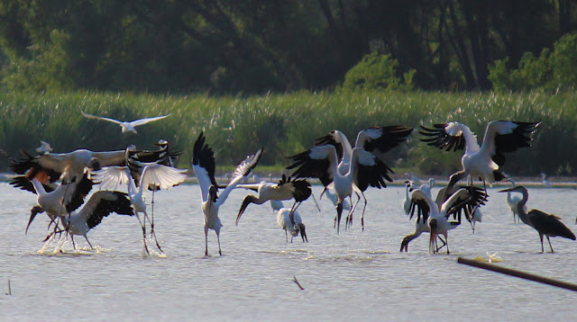 |
| Wood Storks in a feeding frenzy at Lemmon Lake |
The journey to find out more about this place has been an interesting one, taking some interesting turns as I dig deep into a history murkier, cloudier and more mysterious than the Trinity River itself.
 |
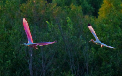
| Roseate Spoonbills in evening flight over the Trinity River |
This is a piece of Texas countryside that is in its original natural state, one the way it looked before pioneers came to stay. Looking into how old the lake might be, I have referenced maps well back into the 1800’s noting the lake. Whether it was an old oxbow river channel turned lake, a natural lake improved upon or a naturally blocked mouth of Five Mile Creek is a mystery yet to be solved. It’s not so much what pioneers left. It’s what the inhabitants of this place thousands of years ago left behind in weird spots near here that leave more questions than answers.
Warren Angus Ferris — Mountain Man Surveyor of Dallas County
 |
| Warren Angus Ferris Cemetery Marker corner of St. Francis and San Leonardo |
Many of the unsolved questions I have are being answered by a man who died in 1873. Warren Angus Ferris. Perhaps you have not heard of him. His name does not exist on a road sign, a school, a park or a plaza anywhere in Dallas. Ferris is not only long forgotten in Dallas history but even his final resting place in the Forest Hills Neighborhood was bulldozed over and had homes built on it. I have road cycled from White Rock Lake east out to Sunnyvale, hundreds of times on the Richardson Bike Mart route that passes by the cemetery. The Historical Marker that notes the cemetery was covered by Chinese Privet brush and the cemetery so unkept I never knew it existed. Cemetery census courtesy of the late Jim Wheat’s website W.A. Ferris Cemetery Census says over 100 souls are buried here with the last one in 1906.
Warren Ferris was originally from Buffalo, New York and was the official surveyor for Nacogdoches County, Republic of Texas. At the age of 27, he was tasked with surveying what we now call Dallas County, east of the Trinity River. Beginning in 1839, he built a base camp along White Rock Creek to survey the lands for the Republic, for veterans of the Texas Revolution who were guaranteed a league and a labor of land for their war service. Many of the ex-soldiers never saw the land parceled for them. They exchanged their titles for cash or other lands held by real estate holding companies elsewhere.
Ferris led a survey crew of well armed men, sometimes as many as sixty men split into three 20 man divisions. They were given the tough task of surveying the wilds of the Three Forks of the Rio Trinidad, ripe with Indians and wild animals. In each survey team were not just surveyors but trappers, hunters, scouts and cooks. Traveling light and living off the land, they ate a diet of mostly red meat from the abundant animal life in Dallas County at the time.
Ferris was no stranger to wild environments. Prior to being hired as offical surveyor, he surveyed what is now Yellowstone in Wyoming and Montana as a 19 year old hired by the American Fur Company. He kept a daily diary of his travels in the Yellowstone country which was later compiled into one of the single greatest books on Mountain Men in North America. His book entitled Introduction to Life in the Rocky Mountains by W.A. Ferris still serves today as a Rosetta Stone into the lives of the fur trapping trade in 1830-1835. You can read his journal here Introduction To Life In The Rocky Mountains . He described in detail the Battle of Pierre’s Hole against the Blackfeet, grizzly bears, wolves, geysers, half starved to death, you name it. So vivid in detail was he about the Indians and their customs that his journal still serves as a gold standard reference to Native American cultures in the Central and Northern Rockies.
Even more remarkable is his “Map of the Northwest Fur Country,” drawn in 1836. It was made available in 1940 with editorial notes by a man named Dr Paul Phillips for publication with the journals. Dr. Phillips noted this was “the most detailed and accurate of all the early maps of the region,” far superior in accuracy to the famous maps by Bonneville, Parker, John C. Fremont, and others which were published in the same era. The text of the journal, together with the map, suggests that Ferris witnessed and described Old Faithful, the geyser which has become the symbol of Yellowstone National Park.
I mention all this because he also kept a diary of his exploration and adventures in Dallas County too. He writes of his first trip into what is now Dallas:
Everywhere deer, turkeys and prairie chickens were as thick as ants on a hill, with bear, panthers, wolves and wildcats keeping in the daytime to the river and creek bottoms, but after dark issuing forth to ravage the plains and startle the night with uncouth shadows, and hideous screaming and howling.
I saw in the picturesque regions there much of the wild soul-stirring scenes with which I had been so familiar in the Mountains. Thousands of buffalo and wild horses were everywhere to be met with. Deer and turkeys always in view and occasional bear would sometimes cross our path. Wolves and buzzards became our familiar acquaintances and in the river we found abundance of fish from minnows to 8 footers. The prairies are boundless and present a most beautiful appearance being extremely fertile and crowned with flowers of every hue.
He ran into just as many fierce Indians in Yellowstone as he did in Dallas. Only the names and the places changed. The Comanche and Kichai were a constant shadow to his small survey crew across what is now North Dallas. Near daily contact and skirmishes were the norm rather than the exception. Many of his men would often abandon the survey parties due to the Indian raids and flee back to East Texas.
If you live in East Dallas or North Dallas, Warren Ferris walked your property. He might have camped there too. Ferris used the Texas system of surveying. This was an offshoot of Spanish Land Grant surveying that used a 55 1/2 foot chain and a compass. The Vara Chain it was called, used 20 lengths, 20 varas as the measurement. Ferris and his men measured 55 1/2 feet at a time from one end of Dallas to the other and back again.
Ferris surveyed Dallas in 1839-1842 on at least half a dozen trips.
1839-First exploration of Trinity River on east bank and White Rock Creek
October 1840-Setup base camp on east bank of Trinity River near mouth of White Rock Creek and surveyed much of what is now SE Dallas County
Winter 1841-Surveyed what is now Downtown Dallas, Design District, Love Field
May 1841-Richardson, Garland
June 1841-The Lagow League what is now Fair Park
July 1841- Ferris served as chief scout under General Tarrant and General Smith in an Indian campaign across what is now Dallas and Tarrant counties
October 1841- Setup base camp at what is now Presbyterian Hospital and surveyed Upper White Rock Creek
January 1842-Seagoville, Sunnyvale
Warren Ferris settled not far from the present day Arboretum on what is now St Francis in Forest Hills. Since it was illegal at the time for surveyors to purchase land they were working on, his land holdings were placed in the name of his half brother, Joshua Lovejoy. There he raised a family of nine children, built a grist mill near the present day White Rock Lake Spillway and served in the Confederate Army as a member of the White Rock Mounted Rifles. One of the first four cotton farmers in North Texas, his crop was the first to be floated down the Trinity River some seventy miles to market.
Hopefully I can get the detailed manuscripts of his travels, soon. They sit in Nacogdoches, Texas at the moment. Ferris in his surveying, noted spring locations, Indian trails, General Rusk’s route across lower White Rock, hard bottom stream crossing sites, timber breaks and many other natural features that either once existed or still exist today. One of which is the natural water feature now called Lemmon Lake.
 |
| Lemmon Lake and the diversity of birds feeding |
Bill Barrett — The Coors Beer Philanthropist
Many of the photos I have taken this summer would not be possible without the enormous gift Bill Barrett bestowed on the City of Dallas in the 1980s. He purchased Lemmon Lake and some of the surrounding land to preserve the unique nature and environment there. In the 1980s this area was threatened with the development of a concrete factory and expansion. Mr Barrett’s purchase saved the lake and surrounding woods. When I have taken friends mountain biking or hiking down here I tell them that this is what the Coors sold in Dallas during the 70s and early 80s bought. Bill Barrett owned Willow Distributors, the Dallas distributor for Coors at the corner of Grand and Lamar. Now known as Andrews, the facility sits a stone throw from the Santa Fe Trestle Trail on the north bank of the Trinity River.
It would be considered by many this time of year, even Native Dallasites a place that is foreign to them. The tropical breezes that blow in weird birds. Weird colored birds with funny shapes, funny sizes and funny sounds.
Waiting for the birds to come off their day roosts to feed in the evening you have time to sit, ponder, reflect on what makes this whole place tick. Sitting in the shade of Old Growth Oaks among old chards of chert and ancient cooking fires you develop a connection with whoever sat there a thousand years before around dinner time. Same view I would imagine.
It’s out on the far eastern horizon where you see them first. Lumbering in among the storm clouds, hundreds of feet, maybe a thousand feet high at first soaring in to feed. The heat of the day broken, they come to feast on the quickly drying lake where I sit.
 |
| High flying Wood Storks under an appraoching storm |
The draw for the Wood Storks is the perfect knee deep water that wading birds need to feed. At Lemmon Lake that -perfect- water depth only lasts a week or two, slowly giving way to more challenging fishing.
 |
| Wood Storks |
I looked around for some good video of Wood Storks feeding but could not find any. In North America the Wood Storks are few and far between. Most of the video I have seen features Wood Storks on roosts or standing on front lawns in Florida. In the winter months, the Lemmon Lake birds head back to the Amazon Basin mostly likely where someone with a camera is not likely to venture.
So…below is a video of Wood Storks feeding at Lemmon Lake. If you watch the video closely you can see how they move through the water with their beak open. They fish by feel not by sight. Wood Storks have the fastest beak closing reaction time among any birds in the world, a fraction of a second. Feeding mostly on crawfish and small bait fish, they can eat pounds of fish in an hour using this technique.
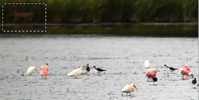
A number of times I was caught up in summer rains. Not showers that just knock the dust down. Real rain. Driven walls of water that electrify the air with lightning and wind. That brings out the predators. Highlighted in the white dashed box below is a coyote prowling the shoreline looking for an unsuspecting bird for dinner. The video of the coyote is below in the video starting at about the 5 second mark and moving left to right….
The lightning in this particular storm was cloud-to-cloud and given the damp nature of the air reverberated over and over and over again while filming this clip.
As the storms collapse after the heat of the day is gone and the cool outflow boundary drops the temperature out of the triple digits, the larger animals appear out of the woods. You can set your watch by it. Lumbering out of what was probably a long afternoon nap the feral hogs of the Great Trinity Forest make their way down to the shoreline for a drink.
Few in number at first, as the sun lowers more and more appear. Tolerated at first by the birds, the number of pigs becomes too great and sends the Wood Storks and Spoonbills to their night roosts in the tall cottonwood trees along the banks of the Trinity River.
 |
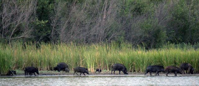
| Pig sounder with young’ens at Lemmon Lake |
Some of the adults in this sounder, like many Texas Feral Hogs have Hampshire markings from their domesticated ancestors many generations ago. Longer snouts, longer legs, bigger eyes and ears make the wild feral hog version of a domesticated pig a force to be reckoned with.
Below is video of one feral pig sounder in action. Moving up and down the shore looking for freshwater shelled animals, eggs, tuber roots, carrion, whatever they come across.
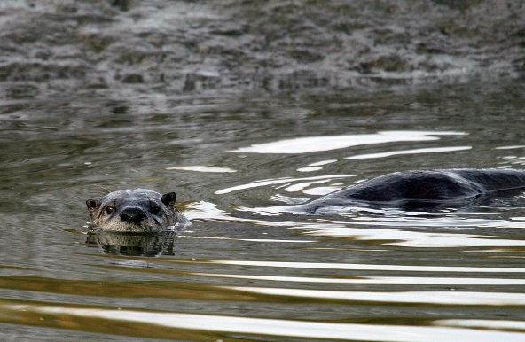
River Otters are something new for 2012 in the Great Trinity Forest too. I think that I have gotten a good glimpse or two of them in the past but never like I have in 2012. The otters in late July and early August made a transition from Lemmon Lake to Little Lemmon Lake, seen in the photo below taken the evening of August 1, 2012.
Hopefully the otters, rumored to be a family of four, take up residence here. Playful and interesting to watch I think quite a few people would get a kick out of seeing them somewhere other than a zoo. Little Lemmon Lake or the Wetland Cells north of Loop 12 would be an ideal environment for them to flourish in.


